CSEC
Do you know?
Water Resources Management
Are we ready for climate change
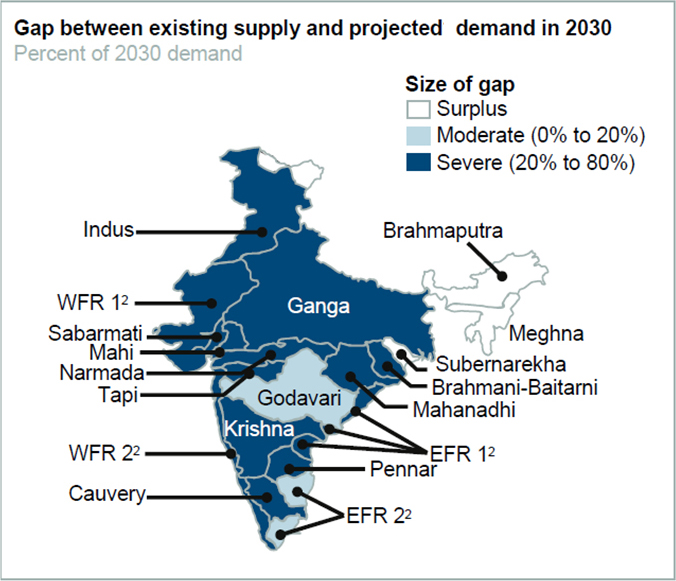
Water is a finite resource. To support rising demand of water due to population growth, urbanization and change in agricultural pattern there is a need of economic use of water resources, to ensure water for every human being and sustainable progress. A large number of initiatives and reforms have been undertaken at the policy level by the government of India to address the challenges in water sector. This includes formulatinggeneral policies on water resource developmentand providing technical assistance to all states in irrigation, multipurpose projects, groundwaterexploration and exploitation, command areadevelopment, drainage, flood control, waterlogging, coastal and riverbank erosion problems,dam safety and hydraulic structures for navigationand hydropower. India has also undertaken considerable investments for infrastructure development of large dams, storage structures, and canal networks to meet the country’s water and agricultural needs, particularly in support of technology-based interventions to improve agricultural production. However, there are still gap between the supply and demand of water across different sectors. The ‘Water Gap’ for India estimated by the‘2030 Water Resource Group’ is analarming50 % (Figure 5).
Figure 6 India water supply and demand gap (WFR = western-flowing coastal rivers; EFR = eastern-flowing coastal rivers) ( Addams, et al. 2009)
To counter the challenges in the water sector followings are the major policy level interventions adopted by the Government of India.
National water policy
National Water Policy was first formulated in September, 1987 by the Ministry of Water Resources of the Government of India to govern the planning and development of water resources and their optimum utilization. It was reviewed and updated in 2002 and later in 2012.
"The objective of the National Water Policy is to take cognizance of the existing situation, to propose a framework for creation of a system of laws and institutions and for a plan of action with a unified national perspective."
In the first National Water Policy (1987) more stress were given on areas such as developing information system on water for resources, water resources development planning to sub-basin level, maximizing availability and minimizing loss of water, maintenance and modernization of water infrastructure and their safety, ground water development, providing adequate drinking water to the population and developing cost-effective irrigation system. Allocation priorities of water among different sectors was decided along with incorporation of water rates to motivate economy in water use. Disaster management such as planning of flood control, drought management, management of coastal and river erosion, water quality monitoring also given priority in this policy. Water conservation through education, regulations and incentives also promoted in the policy. It also mentioned that capacity building and use of science and technology should be integral part of countries water resources management plan.
The National Water Policy (NWP 2002) was subsequently introduced in relation to the rapidly changing scenario in the domain of water to address the emerging issues and provide critical policy inputs. NWP 2002 gave emphasis for the first time to ecological and environmental aspects of water allocation.
The National Water Policy (NWP 2012) calls for a common integrated perspective to govern the planning and management of water resources. Such a perspective would consider local, regional, and national contexts and be environmentally sound. Some of the guiding principles stated in the NWP 2012 include:
- The principle of equity and social justice must inform the use and allocation of water resources. Planning, development and management of water resources need to be governed by common integrated perspectives considering local, regional, and national context, having an environmentally sound basis, keeping in view the human, social and economic needs.
- Safe drinking water and water for sanitation should be considered as pre-emptive needs, followed by high priority allocation for other basic domestic needs, supporting agriculture for food security and minimum ecosystem needs. After meeting the previously mentioned needs, water should be allocated in a manner to promote its conservation and efficient use.
The NWP makes recommendations on several major issues including: Adapting to climate change, Enhancing water availability, Water demand management through efficient water use practices, Water pricing, Conservation of river corridors, Water bodies and infrastructure, Project planning and implementation, Management of floods and droughts, Water supply and sanitation, Institutional arrangements, Trans-boundary rivers, Database and information system, Research and training needs, Preparation of a plan of action by the National Water Board based on the National Water Policy.
Water being a State subject, States and local government institutions ultimately have to manage the proper use of local resources, and local communities and local governance institutions and Panchayats and Municipalities have to work in coordination with each other and the State departments concerned for resource management. In view of that State Government are formulizing their water policies by identifying State level priorities based on State level conditions, policies, and prospects of industrialization, urbanization, etc.
National Water Mission
The main objective of the National Water Mission (NWM) is “conservation of water, minimizing wastage and ensuring its more equitable distribution both across and within States through integrated water resources development and management”. The five identified goals of the Mission are: (a) comprehensive water database in public domain and assessment of impact of climate change on water resource; (b) promotion of citizen and state action for water conservation, augmentation and preservation; (c) focused attention to vulnerable areas including over-exploited areas; (d) increasing water use efficiency by 20%, and (e) promotion of basin level integrated water resources management. NWM involves active participation from all the stakeholders to develop integrated planning for sustainable development of country’s water resources and identify climate-smart management practices.
National Ground Water Management Improvement Programme
With the support from World Bank, Government of India initiated this programme to address the issues of growing threats to ground water resource availability and its quality.The objective of this programme is to “improve the management of groundwater resources in selected States.” 7States (Gujarat, Maharashtra, Haryana, Karnataka, Rajasthan, Uttar Pradesh and Madhya Pradesh) have been selected to participate in this Program. These States have some of the most heavily exploited groundwater areas in India, and confrontserious availability and quality problems that are expected to intensify in the future and might, unless addressed, be irreversible.
Flood Management Programme
Under "Flood Management Programme", critical flood control, river management and anti-sea erosion works in the entire country would be covered. These works would include the works related to river management, flood control, anti-erosion, drainage development, flood proofing, flood prone area development programme in critical regions, restoration of flood control/ management works damaged due to force measures like anti-sea erosion and catchment area treatment.
Flood forecasting has been recognized as one of the most important, reliable and cost-effective non-structural measures for flood management.Central Water Commission (CWC), Ministry of Water Resources has set up a network of forecasting stations covering all important flood prone inter-state rivers. The forecasts issued by these stations are used to enable the local administration to take suitable administrative measures like evacuation of people from flood affected areas to safer locations during flood season and also to enable the project authorities carry on proper operation of reservoirs.
Integrated Watershed Management Programme (IWMP)
The main objectives of the IWMP are to restore the ecological balance by harnessing, conserving and developing degraded natural resources such as soil, vegetative cover and water. The outcomes are prevention of soil run-off, regeneration of natural vegetation, rain water harvesting and recharging of the ground water table. This enables multi-cropping and the introduction of diverse agro-based activities, which help to provide sustainable livelihoods to the people residing in the watershed area. In addition, there is a Scheme of Technology Development and Extension and Training (TDET) which are also being implemented to promote development of cost effective and proven technologies to support watershed management.
Till 2008, Department implemented 3 watershed programmes viz. Integrated Wastelands Development Programme, Drought Prone Areas Programme, Desert Development Programme. Since then, they have been brought under a comprehensive programme named Integrated Watershed Management Programme (IWMP) to be implemented under Common Guidelines on Watershed Development, 2008.
National Rural Drinking Water Programme (NRDWP)
Initiated in 2009 NRDWP aims at providing safe and adequate drinking water to every rural person. The goal of this programme is to "ensure, that every rural person has enough safe water for drinking, cooking and other domestic needs as well as for livestock throughout the year including during natural disasters and, by 2022, every rural person in the country will have access to 70 lpcd within their household premises or at a horizontal or vertical distance of not more than 50 meters from their household without barriers of social or financial discrimination. Individual States can adopt higher quantity norms, such as 100 lpcd."
India-Water Resources Information System
The project "Generation of Database and Implementation of Web Enabled Water Resources Information System in the Country" named as India-WRIS WebGIS is a joint venture of the Central Water Commission (CWC), Ministry of Water Resources, Govt. of India and Indian Space Research Organization (ISRO), Department of Space, Govt. of India, as per the Memorandum of Understanding (MOU) signed on December 3, 2008 between the two departments for a period of four years - January 2009 to December 2012 and has been extended till December, 2017. The project is funded by Central Water Commission.
India-WRIS WebGIS aims as a 'Single Window' solution for comprehensive, authoritative and consistent data & information on India’s water resources along with allied natural resources in a standardized national GIS framework (WGS-84 datum and LCC projection) tools to search, access, visualize, understand and analyse the data for assessment, monitoring, planning, development and finally Integrated Water Resources Management (IWRM).
National Mission for Clean Ganga
NMCG is a registered society under Ministry of Water Resources. The aims and objectives of NMCG is to accomplish the mandate of National Ganga River Basin Authority (NGRBA), which are (i) to ensure effective abatement of pollution and rejuvenation of the river Ganga by adopting a river basin approach to promote inter-sectoral co-ordination for comprehensive planning and management and (ii) to maintain minimum ecological flows in the river Ganga with the aim of ensuring water quality and environmentally sustainable development.
Traditional practices
Water conservation is a key element of any strategy that aims to alleviate water scarcity crisis in India. To cope up with the variable rainfall pattern and regular occurrence of flood and drought events government is now looking back to revive historical water management practices. Water harvesting is the deliberate collection and storage of water that runs off on natural or manmade catchment areas. Catchment includes rooftops, compounds, rocky surface, hill slopes or artificially prepared impervious/ semi-pervious land surface. Water harvesting is especially useful in semi-arid regions where irrigation water is not available regularly. India has a great and long tradition of water harvesting. Some of the traditional water harvesting systems are given below.
- Bamboo pipes: Bamboo drip irrigation system is an ingenious system of efficient water management that has been practised for over two centuries in northeast India, especially hilly regions like Meghalaya. Bamboo pipes are used to divert perennial springs on the hilltops to the lower regions by gravity.
- Apatani: Apatanis can tap several small streams and springs hill regions by making temporary walls, which act as barriers and can divert the flow of water towards terraced and valley lands. It was practiced in gentle sloping valleys with moderate annual rainfall.
- Ghul: In the high altitude of Himalayan region, water is tapped from hill slops known as ghuls. These ghuls ranges in length from 1 to 15 km. and carries a discharge of 15-100 liter of water/ sec. In Western Himalaya region comprising Jammu, Himachal Pradesh and Northern Uttaranchal, ghul is a standard harvesting technique.
- Zabo: Zabo is practiced in Nagaland. It is basically an agroforestry system which combines water conservation with forestry, agriculture and animal care system. Rainwater that falls on forested hilltops is collected by channels that deposit the run-off water in pond-like structures created on the terraced hillsides.
- Cheo-Ozihi: In this system river water is tapped in seven different places in different elevations by means of channel diversion and practiced in Nagaland.
- Dongs: Dongs are ponds constructed by the Bodo tribes of Assam to harvest water for irrigation. Water is lifted from the ponds and distributed into the fields.
- Garh & Dara: In Assam, the garh is a type of nala built to channelize river water to the agricultural field. Dara are the embankments aerated in the paddy fields to store rainwater.
- Ahar Pynes: This traditional floodwater harvesting system is indigenous to south Bihar and functions by using the land slope. Pynes are artificial rivulets led off from rivers to collect water in the ahars for irrigation in the dry months.
- Bengal's inundation channels: It is an overflow irrigation system which makes use of the abundant water of Ganges and Damodar. Long canals are made from the rivers with cuts in the banks of the canals to facilitate flood water to enter the fields. They were closed when floods recedes.
- Kunds: A kund is a saucer-shaped catchment area that gently slope towards the central circular underground well. Its main purpose is to harvest rainwater for drinking. They are generally found in Rajasthan and Gujarat.
- Khadins: Khadins are constructions designed to harvest surface runoff water for agriculture. They were first designed by the Paliwal Brahmins of Jaisalmer in the 15th century.
- Talabs & tankas: Talab is a local name of a water harvesting structure used as reservoir situated in valleys and natural depressions. Tankas (small tank) are underground structures and are mostly found in the houses of Bikaner. The water was used only for drinking purpose.
- Stepwell or baoli: The step well can be considered to originate from the need to ensure water during the period of drought. These are wells or ponds in which the water can be reached by descending a set of steps. Jhalara is also a local name given to step wells. Jhalaras were human made tanks, found in Rajasthan and Gujarat, essentially meant for community use and for religious rites.
- Eri: The Eri (tank) system of Tamil Nadu is one of the oldest water management systems in India. Still widely used in the state, Eris act as flood-control systems, prevent soil erosion, check wastage of runoff during periods of heavy rainfall and also recharge the groundwater. Eris can either be a system Eri, which is fed by channels that divert river water, or a non-system Eri, that is fed solely by rain. The tanks are interconnected in order to enable access to the farthest village and to balance the water level in case of excess supply. The Eri system enables the complete use of river water for irrigation and without them paddy cultivation would have been impossible in Tamil Nadu.
- Jackwells: They are found in the Andaman and Nicobar islands. In lower parts of the undulating terrain, bunds were made by using logs of hard bullet wood. A full length of bamboo is cut longitudinally and placed along a gentle slope with the lower end leading into a shallow pit. These serve as channels for rainwater which is collected drop by drop in pits.